# Extract S5p footprint
**URL:** https://forum.atmospherictoolbox.org/t/extract-s5p-footprint/256
**Category:** HARP
**Tags:** sentinel-5p, python
**Created:** [January 25, 2021, 9:32am UTC](https://forum.atmospherictoolbox.org/t/extract-s5p-footprint/256 "2021-01-25T09:32:46Z")
**Posts on this page:** 5
**Page:** 1
### Author:  [@user231093](https://forum.atmospherictoolbox.org/u/user231093)
#### Post date: [January 25, 2021, 9:32am UTC](https://forum.atmospherictoolbox.org/t/extract-s5p-footprint/256/1 "2021-01-25T09:32:46Z")
Hi,
When working with S-5p L2 S02 products in Python, I want to extract some key metadata before sendint it to HARP processing. I am wondering in which group / sub-group can the footprint be found? Checking the documentation of the user manual it seems to be in `eop:multiExtentOf” in “om:featureOfInterest”` but when accessing it (in Python) I cannot manage to actually see the coordinates? What can I be missing here?
Here the documen - Page 92 - 12.29.1.9 Group “eop:multiExtentOf” in “om:featureOfInterest”
[https://sentinel.esa.int/documents/247904/2474726/Sentinel-5P-Level-2-Product-User-Manual-Sulphur-Dioxide](https://sentinel.esa.int/documents/247904/2474726/Sentinel-5P-Level-2-Product-User-Manual-Sulphur-Dioxide)
Thank you,
M
---
### Author:  [@sander.niemeijer](https://forum.atmospherictoolbox.org/u/sander.niemeijer)
#### Post date: [January 25, 2021, 10:28am UTC](https://forum.atmospherictoolbox.org/t/extract-s5p-footprint/256/2 "2021-01-25T10:28:03Z")
You won’t be able to extract such information with HARP.
You will need to use a lower-level reading library such as the netCDF4 library or CODA.
With CODA you can extract this polygon using:
```
import coda
pf = coda.open('S5P_OFFL_L2 __SO2____ 20210123T044200_20210123T062330_16994_01_020104_20210125T073338.nc')
poslist = coda.fetch(pf, '/METADATA/EOP_METADATA/om_featureOfInterest/eop_multiExtentOf/gml_surfaceMembers/gml_exterior@gml_poslist')
coda.close(pf)
lat = [float(p) for p in poslist.split(" ")[::2]]
lon = [float(p) for p in poslist.split(" ")[1::2]]
```
---
### Author:  [@user231093](https://forum.atmospherictoolbox.org/u/user231093)
#### Post date: [January 25, 2021, 11:04am UTC](https://forum.atmospherictoolbox.org/t/extract-s5p-footprint/256/3 "2021-01-25T11:04:14Z")
I was navigating the metadata attrs and did not see it before 🙂 Thanks for the code example
---
### Author:  [@user231093](https://forum.atmospherictoolbox.org/u/user231093)
#### Post date: [February 8, 2021, 4:03pm UTC](https://forum.atmospherictoolbox.org/t/extract-s5p-footprint/256/4 "2021-02-08T16:03:57Z")
Hi,
After extracting the coordinates from the product metadata and arranging it into a list I get:
> ((45.154247, 119.67357),
> (46.845333, 121.03921),
> (48.51579, 122.50277),
> (50.16308, 124.074814),
> (51.784256, 125.767334),
> (53.375854, 127.593956),
> (54.93387, 129.5701),
> (56.453674, 131.71194),
> (57.92967, 134.03885),
> (59.355755, 136.57037),
> (60.724674, 139.32736),
> (62.027946, 142.332),
> (63.256054, 145.60516),
> (64.398315, 149.1658),
> (65.44262, 153.02882),
> (66.37613, 157.20143),
> (67.18522, 161.68002),
> (67.85633, 166.44713),
> (68.376595, 171.46803),
> (68.73491, 176.68976),
> (68.92327, -177.9573),
> (68.93687, -172.55469),
> (68.7755, -167.18857),
> (68.443115, -161.94177),
> (67.94735, -156.88625),
> (67.29887, -152.07722),
> (66.51049, -147.55257),
> (65.595535, -143.3323),
> (64.567856, -139.42177),
> (63.440296, -135.81503),
> (62.22504, -132.49861),
> (60.93313, -129.45386),
> (59.574245, -126.659805),
> (58.156925, -124.09468),
> (56.68866, -121.73724),
> (55.175667, -119.5676),
> (53.62378, -117.56656),
> (52.037598, -115.71728),
> (50.42116, -114.004524),
> (48.7781, -112.41413),
> (47.1114, -110.93403),
> (45.42381, -109.553024),
> (43.717434, -108.26171),
> (41.994366, -107.051216),
> (40.25641, -105.91394),
> (38.50504, -104.84301),
> (36.741394, -103.83293),
> (34.966896, -102.87781),
> (33.182552, -101.97292),
> (31.38931, -101.11413),
> (29.58787, -100.29776),
> (27.778975, -99.52048),
> (25.963507, -98.778885),
> (24.14186, -98.070694),
> (22.314709, -97.39304),
> (20.48248, -96.744095),
> (18.645742, -96.121605),
> (16.804811, -95.52389),
> (14.960076, -94.949425),
> (13.111927, -94.3966),
> (11.26071, -93.86419),
> (9.406724, -93.351006),
> (7.5502887, -92.85586),
> (5.6916103, -92.37787),
> (3.8310509, -91.91616),
> (1.968744, -91.46994),
> (0.10495859, -91.03856),
> (-1.7600541, -90.62111),
> (-3.6260984, -90.217186),
> (-5.493023, -89.82644),
> (-7.3605785, -89.448135),
> (-9.22869, -89.0823),
> (-11.097062, -88.72814),
> (-12.965643, -88.385635),
> (-14.834206, -88.05445),
> (-16.702625, -87.73457),
> (-18.570791, -87.42558),
> (-20.438416, -87.127754),
> (-22.305588, -86.84095),
> (-24.172117, -86.565445),
> (-26.037745, -86.30077),
> (-27.902737, -86.048096),
> (-29.766478, -85.806496),
> (-31.629223, -85.57715),
> (-33.490734, -85.36021),
> (-35.350983, -85.15653),
> (-37.209877, -84.96657),
> (-39.067196, -84.790924),
> (-40.923077, -84.630806),
> (-42.777252, -84.487404),
> (-44.62972, -84.36219),
> (-46.480392, -84.256714),
> (-48.32907, -84.17275),
> (-50.175816, -84.113304),
> (-52.020435, -84.08061),
> (-53.86276, -84.07897),
> (-55.702713, -84.11183),
> (-57.540134, -84.18562),
> (-59.37466, -84.30592),
> (-61.20618, -84.48135),
> (-63.034313, -84.72287),
> (-64.85858, -85.04391),
> (-66.678345, -85.462425),
> (-68.492935, -86.00242),
> (-70.30109, -86.69637),
> (-72.101425, -87.58867),
> (-73.89152, -88.74611),
> (-75.66804, -90.26319),
> (-77.4256, -92.287254),
> (-77.716125, -92.68896),
> (-77.72833, -92.27399),
> (-77.840775, -84.61106),
> (-77.58821, -72.35083),
> (-77.18361, -65.13743),
> (-76.68611, -59.099934),
> (-76.25827, -54.991444),
> (-75.78745, -51.142197),
> (-75.38962, -48.269863),
> (-74.94513, -45.368332),
> (-74.558914, -43.05807),
> (-74.15006, -40.78874),
> (-74.11242, -40.58793),
> (-73.709625, -38.515705),
> (-73.22472, -36.188194),
> (-72.76765, -34.13902),
> (-72.18967, -31.72253),
> (-71.61333, -29.484955),
> (-70.83308, -26.699516),
> (-69.98643, -23.961155),
> (-68.70218, -20.299837),
> (-67.06496, -16.348957),
> (-65.58033, -13.320927),
> (-65.58033, -13.320927),
> (-64.56785, -17.2311),
> (-63.455616, -20.841757),
> (-62.255627, -24.166136),
> (-60.97866, -27.22156),
> (-59.634274, -30.028065),
> (-58.231125, -32.60701),
> (-56.77655, -34.97899),
> (-55.276833, -37.163925),
> (-53.737698, -39.180073),
> (-52.16376, -41.044346),
> (-50.559277, -42.77225),
> (-48.927708, -44.377487),
> (-47.272083, -45.871933),
> (-45.59506, -47.26704),
> (-43.898968, -48.572075),
> (-42.185806, -49.79573),
> (-40.45735, -50.945942),
> (-38.715115, -52.029285),
> (-36.960487, -53.051823),
> (-35.194603, -54.018837),
> (-33.4186, -54.935455),
> (-31.633278, -55.805458),
> (-29.839544, -56.632828),
> (-28.038218, -57.421303),
> (-26.229906, -58.173428),
> (-24.41527, -58.892235),
> (-22.594791, -59.580193),
> (-20.769045, -60.23931),
> (-18.9385, -60.87214),
> (-17.103544, -61.47985),
> (-15.264486, -62.064323),
> (-13.422023, -62.62739),
> (-11.576046, -63.169685),
> (-9.727102, -63.69292),
> (-7.875425, -64.19801),
> (-6.0214553, -64.68619),
> (-4.165145, -65.15811),
> (-2.3070114, -65.61475),
> (-0.44709745, -66.056786),
> (1.4142969, -66.484695),
> (3.276973, -66.899414),
> (5.1407504, -67.30129),
> (7.0054536, -67.69079),
> (8.870922, -68.06848),
> (10.736962, -68.43458),
> (12.603467, -68.7894),
> (14.47019, -69.133286),
> (16.337086, -69.46631),
> (18.20399, -69.78891),
> (20.070774, -70.10101),
> (21.937365, -70.402405),
> (23.803625, -70.69359),
> (25.669443, -70.97437),
> (27.534664, -71.244354),
> (29.39928, -71.50352),
> (31.26316, -71.75164),
> (33.126232, -71.98852),
> (34.988415, -72.21344),
> (36.8496, -72.42606),
> (38.709812, -72.62541),
> (40.56886, -72.81114),
> (42.426743, -72.981865),
> (44.283367, -73.13672),
> (46.138756, -73.27415),
> (47.9927, -73.39245),
> (49.84517, -73.489555),
> (51.6962, -73.56303),
> (53.54556, -73.60979),
> (55.39317, -73.626465),
> (57.238953, -73.608185),
> (59.082703, -73.5494),
> (60.92428, -73.44286),
> (62.763355, -73.27973),
> (64.59973, -73.04802),
> (66.432816, -72.73263),
> (68.26213, -72.312904),
> (70.086845, -71.76125),
> (71.905846, -71.03845),
> (73.717285, -70.08798),
> (75.51872, -68.827415),
> (77.30623, -67.12778),
> (79.07308, -64.779854),
> (80.80769, -61.42689),
> (82.48791, -56.414154),
> (84.067665, -48.47269),
> (85.44124, -35.116985),
> (86.36732, -12.749498),
> (86.47327, 16.824577),
> (85.69809, 41.40333),
> (84.396034, 56.463005),
> (82.84921, 65.33879),
> (81.185135, 70.860985),
> (79.45905, 74.5117),
> (77.696815, 77.04446),
> (75.91165, 78.86588),
> (74.11121, 80.21039),
> (72.29971, 81.22076),
> (70.48017, 81.9879),
> (68.65432, 82.57327),
> (66.82349, 83.018776),
> (64.988525, 83.35461),
> (63.150116, 83.60224),
> (61.308693, 83.77868),
> (59.464634, 83.8959),
> (57.61816, 83.96353),
> (55.769524, 83.989174),
> (53.919014, 83.978386),
> (52.066616, 83.9367),
> (51.757725, 83.92702),
> (51.743507, 84.057816),
> (51.43171, 86.64428),
> (50.87817, 90.41686),
> (50.483963, 92.75794),
> (50.108562, 94.84338),
> (49.827972, 96.35039),
> (49.54647, 97.84077),
> (49.324776, 99.00938),
> (49.090702, 100.24454),
> (48.896862, 101.27091),
> (48.699726, 102.31924),
> (48.68195, 102.41402),
> (48.495235, 103.41211),
> (48.278103, 104.57891),
> (48.07994, 105.64904),
> (47.83675, 106.96661),
> (47.600548, 108.244934),
> (47.287098, 109.92333),
> (46.95004, 111.68031),
> (46.433727, 114.22599),
> (45.74974, 117.28473),
> (45.154247, 119.67357),
> (45.154247, 119.67357))
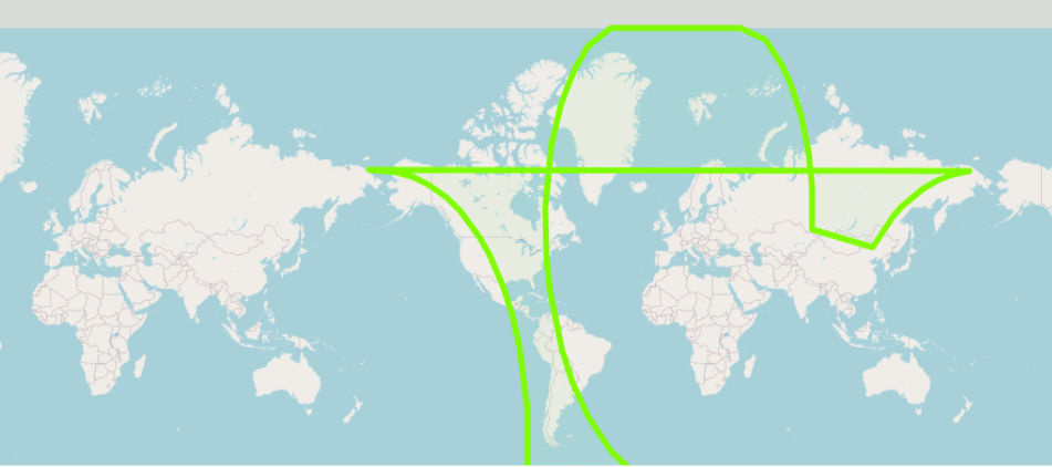
If I then plot this on a map, I get this strange shape in the north:
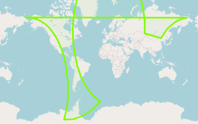
While in the south it looks good:
What can be wrong, as I am ploting the coordinates that come straight from the metadata? What am I missing?
M
---
### Author:  [@sander.niemeijer](https://forum.atmospherictoolbox.org/u/sander.niemeijer)
#### Post date: [February 8, 2021, 4:23pm UTC](https://forum.atmospherictoolbox.org/t/extract-s5p-footprint/256/5 "2021-02-08T16:23:40Z")
There is nothing wrong with the polygon. What is wrong is that you are trying to plot a polygon that is defined using geophysical coordinates (i.e. points a sphere) on a geometric surface (i.e. using a 2D projection). If you want to plot the area (= polygon) on a 2D surface, you will have to take care yourself of the problematic cases, which is when the area covers one or both of the poles, and when the area covers the dateline.
This distinction between geophysical (points are on a sphere, lines are greatcircle segments) and geometric (points are on flat surface, lines are straight lines on the surface) is an important and often overlooked problem.